About Avenel Granite Treks
Avenel Granite Treks are guided geology and nature walks for local residents to experience and learn about the spectacular granite landscapes around Avenel and the Strathbogie Ranges.
The treks are led by experienced local volunteers and renowned geologist Professor Neil Phillips of Melbourne University and the Strathbogie Granite Project.
Through the generosity of local landholders we visit landscapes, outcrops and viewpoints not usually accessible to the general public and learn about the local geology, flora and fauna.

The Strathbogie Granite Project
The Strathbogie Granite Project is a long-term collaboration between Professor Neil Phillips of the University of Melbourne and Professor John Clemens of the University of Stellenbosch in South Africa and their colleagues.
The Strathbogie Granite extends 2000 km2 from Tallarook to Mount Samaria in central Victoria and is globally scientifically important due to the abundance of the mineral cordierite.
The project studies the geology of the iconic granite hills and plateaus of the Strathbogie Ranges, and also provides a valuable baseline for regional ground water, soil, vegetation, rock cover and agriculture studies.
Much project field work has only been possible with the support of landholders and local communities who have provided access to and shared their deep knowledge of the land.
Find out more about the Strathbogie Granite Project:
Join the Avenel Granite Treks
There are usually several Granite Treks each year, in Spring and Autumn.
The treks are for reasonably fit walkers. Young people under 18 years of age are welcome with prior agreement and must be accompanied by an adult parent or guardian.
Each trek is graded using the Australian Walking Track Grading System. Information is provided before each trek about the planned route, distance, duration, local features and participant responsibilities.
A qualified first aider attends each trek. Treks are free to attend.
Participants under the age of 18 years must be accompanied by an adult family member or guardian.
No pets are to be brought on the treks.
Please contact Avenel Active to join the mailing list for the Avenel Granite Treks.
With thanks to Neil Phillips, the Avenel Granite Treks volunteers and participating landholders.
Recent Granite Treks
Light Horse Memorial Park, Seymour - May 2026
This first Avenel Active Guided Trek for 2026 was relatively easy walking and an opportunity to explore the Australian Light Horse Memorial Park which is of great local and national historical significance.
The Park was once the site of the largest Army training camp in Victoria, beginning in 1885 as a training site for the Victorian Mounted Rifles (VMR) who served in the Boer War.
After Federation the VMR became the Australian Light Horse who, along with many other units that trained there, served with distinction in both World Wars. The Camp ceased operations in the 1960s and in 1998 Mitchell Shire Council established the Australian Light Horse Memorial Park to commemorate all who served there.
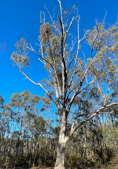
The land in the 140-hectare park has changed compared to how it was pre-European settlement. The site was extensively cleared and military use caused extensive soil disturbance. A few large remnant trees remain, and some dense regrowth forests have emerged which need to be controlled. A trial 4-hectare ecological restoration of Grey Box regrowth has begun, aimed at reducing water runoff and encouraging a diversity of understorey and groundcover plants.
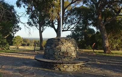
Our route took the Ecological Trail and then on up to Anzac Hill, the highest point in the park. Views of the Tallarook and Strathbogie Ranges and surrounding countryside were spectacular. There is a rock cairn at the summit with native animals and their Aboriginal names on the stones, including the Bunjil (Wedge-tailed eagle). The cairn was built by Howard Mitchell, a regular member of our walking group.
While the Park area does not feature granite - the rock here is siltstone with some sandstone - the surrounding ranges visible from Anzac Hill are granitic. Our geologist guides, Neil Phillips and Peter Mitchell, described the geological features of the aureole (metamorphic zone) surrounding the granite which occurs when the intense heat of rising magma causes recrystallisation and alteration of the surrounding rock (contact metamorphism).
Below is a geologic map prepared by Peter Mitchell. The metamorphic aureole of baked sedimentary layers we observed from Anzac Hill (yellow star) are the stippled black areas and the granite is red. Old sedimentary layers are shown in pink, mauve or purple, basalt flows (on left) are light brown. The mix of greens, yellows and creams are more recent sediments of stratified colluvium on the slopes and, alluvial deposit on the creek flats.
Aureoles often contain distinct metamorphic minerals such as cordierite, which is a magnesium-iron-aluminium silicate mineral. We have been introduced by Neil on previous walks to cordierite, which is a common and defining feature of Strathbogie granite.
We took a detour off the main track to visit the Waler paddock. A Waler is an Australian bred (mixed breed) horse known for its endurance. It was used as a stock horse and as a military remount. However, our reason for visiting the Waler paddock was geological. Excavations for a dam had exposed sedimentary rocks laid down in the sea some 440 to 390 million years ago. The layers of rock were uplifted and contorted around 380 million years ago. What we could see were ridges of siltstone rock exposed after 380 million years of erosion.
As well as Grey Box, there are Red Box and Red Stringy Bark in the Park and a rich diversity of shrub and groundcovers. Controlling the spread of Burgan (Kunzea ericoides) is an ongoing challenge for park managers.
This walk was a leisurely stroll with fascinating descriptions of features of interest. Many thanks to:
-
Our expert guides, Amanda Wylie, Peter Mitchell and Neil Phillips for making this such an informative and interesting walk,
-
Frank Dawson, Kevin Whithear, Peter Mitchell and BEAM Mitchell Environment Group for photos and images, and to
-
John Thomson and Wendy Willingham for organising the walk.
More Information:
Natural Treasures in Mitchell Shire - 6. Australian Light Horse Memorial Park


Mangalore Reserve and Hughes Creek Hill - November 2025
This was one of our easier walks featuring some beautiful, publicly accessible countryside near Avenel. The first part of the walk was through the Mangalore Nature Conservation Reserve a 55Ha area which was mined from 1872 for gravel ballast used in the construction of the north-east railway.
Paradoxically, this disturbance has created a variety of habitats for a wide range of plants from mallee-like trees to many different species of orchids, lilies and ground cover plants. Unfortunately, we arrived a bit late for many of the wildflowers in flower but did see Common Fringe Myrtle (Calytrix tetragona) in full bloom.
For those interested in learning more about this local 'Natural Treasure', the BEAM Enviro Group has published an excellent guide to the Mangalore Nature Conservation Reserve.
The second part of the walk required a 10km drive to the entrance of the Hughes Creek Hill Bushland Reserve. The walk up the hill was not too strenuous and was worth the effort with views of the surrounding countryside plus at the top hill, a wonderful stand of magnificent grasstrees.
Maddie, our first aider on this walk (fortunately her skills not required), taking a break on Hughes Creek Hill.
With thanks to Frank and Helen Dawson and Britta Wallner for photography.


Creightons Creek - September 2025
19 keen walkers set off in good weather on a well-formed track up to the Creightons Creek Bushland Reserve and were rewarded with spectacular views of the surrounding countryside complemented by Neil Phillips' descriptions of large areas of granite representing some of the different types found in the Strathbogie Ranges.
Much of what we saw was a medium grained cordierite granite lacking the very large feldspar minerals we have seen on some other walks. No garnet, a few enclaves (xenoliths brought up from below when the liquid granite rose through the Earth’s crust), but we were lucky enough to see several large sprays of tourmaline up to 30 cm in length.
VicFlora lists 40 different plant species growing in the Bushland Reserve so there was plenty to see for the botanically inclined.
Milkmaids (Wuymbea dioica) were common in the grass. The higher rocky areas had Nodding Blue Lily (Stypandra glauca - below) in flower and a large stand of Cherry Ballart (Exocarpus cupressiformis) which is not that common now. A few Blunt Greenhood Orchids (Pterostylis curta - below) were growing near the lower track. Tree species were mainly Red Stringybark, Long leaf Box and Lightwood. Uplifting a few rocks revealed specimens of Boulenger's Skink and a Marbled Gecko.
The harder part of the walk was kept to the end with a descent from the hill without any track; but this was after a shady spot for a brief rest for lunch that was appreciated.
With thanks to David and Sue Vaughan and Jim Shovelton who gave permission to walk across their properties; to Glenys Pentland, Stephen Onians and Anna Burdett for photography; and to Neil Phillips for giving us his time and knowledge.


Bunding Creek, Avenel - June 2025
The trek followed a similar route to our 2024 Bunding Creek trek, except not traveling as far east to avoid some difficult fences. We followed the laneway east from Mittagong and down into Bunding Creek where the slabs were of typical coarse-grained granite.
Across the creek, over the next ridge and down into the second south-to-north creek, and along that valley towards an obvious saddle. However, just before the saddle the creek turned northwest and dropped more steeply on a completely different course - this was an outstanding example of creek capture and a wind gap. Our valley and walking route had been captured and we were forced northwest towards Bunding Creek; straight ahead is a large open valley.
The creek and valley can be described as misfit with the valley features not being in proportion to the creek flow and any catchment. (Note: the right-hand photo above was taken in June 2024).
The northwest route took us to the confluence with Bunding Creek and a beautiful area of gums, a lunch place, and some most interesting granite with exceptional tourmaline, garnet and cordierite. Following Bunding Creek south and upstream took us through a small gorge with horizontal layers of granite forming cliffs and pools before we exited to the west bank and made our way across country to our start.
The balancing boulders in this final section raised the question of how these boulders result in being stacked one upon another? Find out the answer at the next Granite Trek!
With thanks to the Lawrence and Newton families
for their kind permission to access this beautiful area
and to Stephen Onians for photography.
Where does the name 'Bunding Creek' come from?
Find out about the Bunting family connection to Avenel, with thanks to Frank Bunting.


Good Morning Bill Hill and Mt Tickatory, Ruffy - May 2025
Twenty-one intrepid walkers set off with guides Tim and Andrew Summons, who grew up on the property.
Andrew led us to a particularly old She-oak, a wombat and some caves on the side of Mt Tickatory, all the while talking through the history of the area from pre-1850 onwards.
Good Morning Bill Hill has a large Pinninger Cairn on a subsidiary summit and on Mt Tickatory there was a geodetic marker.
No trouble finding granite with much fine-grained Aplite on Good Morning Bill Hill, and coarser grained granite on Mt Tickatory.
Overall, it was an ideal day for walking being warm and dry, though the farms around would have appreciated some rain. A generally easy Grade 3 walk for most of the time but a somewhat harder sidle around the southside of Mt Tickatory to the cave (which people handled well).


Gawarn Baring, Trawool - August 2024
Gawarn Baring means Echidna Track in the Taungurung language. This walk climbs through mixed eucalypt forest and granite outcrops to the spectacular Trawool reservoir.
Gawarn Baring was developed in partnership between Goulburn Valley Water, Taungurung Land and Waters Council, Biik Cultural Land Management and the Victorian Government.
Bunding Creek, Avenel - June 2024
This walk crossed grazing land and followed a small creek until joining the Bunding Creek, climbing through a small gorge with spectacular granite scenery.

The local geology comprises granite and some hornfels, and shows the power of floods to move rocks and debris around the landscape.
Mt Bernard, Avenel - August 2023
This trek climbed the western slopes of Mt Bernard, crossed the plateau and descended into valley grassy forest on the southeastern slopes.
Along the way the route passed through granitic hills woodland, heathy dry forest and grassy dry forest, each with their own distinctive vegetation and, of course, plenty of granite.

Kong Meng Hill, Avenel - June 2023
This walk was along the edge of the Strathbogie batholith. The geology is dominated by various types of Aplite (very fine-grained granitic rock). Other interesting features were numerous spring systems, dykes and pegmatites. Below Neil Phillips is pointing out coarse grain crystals in a pegmatite.

There was also much for the botanically inclined. Plants seen included Ausfeld's wattle (Acacia ausfeldii), Austral indigo (Indigofera australis), Hickory wattle (A. obliquinervia), Rock isotoma (Isotoma axillaris) and a giant Stringybark, below, possibly Cannon's Stringybark (E. macrorhyncha subsp. cannonii) which is normally restricted to NSW.

